What is a Plat Map?
If you are a real estate agent, or you are in the process of purchasing a house you will need to deal with a lot of paperwork, and one of the papers might be a plat map. What is a plat map? Don’t be scared if you have never heard of it, keep reading this article, and you will find plat maps not scary but very useful.
Generally speaking, a plat map is a diagram showing the boundaries of your future private property in relation to your neighbors and the land surrounding it. On the plat map you will find nearby streets, easements and even flood zones.
When is a Plat Map Required?
A plat map shows what you can legally do on your plot and is typically required in cases like:
- the property is being sold;
- the property is subdivided into smaller plots;
- the property is consolidated into a single plot;
- the property will be turned into a location with a public access (like a park, a road, etc);
- someone has been granted an easement on the property;
- in terms of the city it helps to plan its growth.
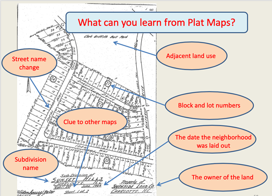
What Can You Learn from a Plat Map?
When you purchase a house you might want to know the exact boundaries and the true size of your property, the opportunities for building additions to your property, and the exact location of your property.
From the plat map you will learn the north, south, west and east sides of your property. It is good to know when you think which side of your future house to choose for your bedroom, if you want to wake up with the first sunbeams in your room.
It is important to get a clear view of any easements on your property, so you're not surprised one day that your fruit garden is a future city roadway.
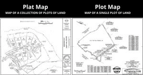
Plat Map vs Plot Map
Though these two sound alike, there is a difference between a plot map and a plat map.
A plat map is a wider notion, it shows all the above mentioned details of the land area, including neighborhood. So it is made up of a collection of plots.
And a plot map is a diagram of a land area with a single purpose like a house. It shows individual property boundaries, setback lines, easements and other specific details on a single plot of land.
Reading a Plat Map
Whether you are buying a house or going to build a new one on the plot you are about to purchase, try to get the most recent plat map and study it carefully.
A plat map is a legal document and should be created by a professional land surveyor and signed by the county.
There is a difference between a platted and unplatted property that you should know. A platted property is the one subdivided into lots for further building development.
A lot of numbers are probably the first thing you will notice on the map. Those are the numbers of streets, and a parcel number in the middle of each property. A parcel number is typically shown in large, underlined bold figures. These numbers are assigned by the county’s assessor’s office.
The so called builder’s lot numbers are assigned to the property by the developer. The numbers along the property line stand for the lot dimensions. The property drawings indicate the shape of the property.
If you still have doubts about the accuracy of the plat map, pay for the land survey and you will get the latest version of the area or at least find the latest map in LandGlide to compare.
Have Your Property Surveyed
When you come to think that the real dimensions are too exaggerated or on the contrary under-estimated on the plat map, you might want to think of the land survey. It is especially important for loan documents; even a small typo will prevent your loan from funding.
Apply to licensed professionals for your land survey, or consult with the specialists of our company for your further steps.
What about the cost? A typical residential land survey will cost around $300 – $1,000. If the land has uneven or difficult terrain with hills, creeks, etc, the cost will grow higher.
The filed plat map is approved by the local government after it’s been reviewed. Zoning rules could differ from area to area. In some areas a plat map must also contain a given amount of land allotted for schools, green areas or any commercial use purposes.
On a good plat map you will also find designated roads. Make sure to see that all your parcels have an access to a public right of way, and not in the middle of other lots without an access to roads.
This prevents the process of selling landlocked parcels of land that have no access or can only be accessed trespassing across other properties.
-
November 29, 2022Is It Cheaper to Build a House - Build VS Buy
-
August 02, 2022What is the difference between a townhouse and a condo?Buying any kind of property is not a piece of cake but a responsibility. Nowadays real estate market is full of proposals from tiny studios to luxurious mansions. To begin with, you need a clear plan of action.
-
October 07, 2022Swimming Pool in the House: Pros and Cons